
Strong tremors in Ranau will continue to be felt especially when the stored energy exceeds the Earth's ability to store it, said an expert.
KUALA LUMPUR: A 6.0-magnitude earthquake rocked Sabah early Friday and it has been cited by Bernama as the strongest to hit the state since 1991.
The US Geological Survey said the quake struck at a depth of 10 kilometres, with its epicentre located 19 kilometres (12 miles) from the town of Ranau and 54 kilometres from Kota Kinabalu.
Malaysia does experience earthquakes but is outside the Ring of Fire, a belt of seismic activity running around the basin of the Pacific Ocean that includes neighbours Indonesia and the Philippines.
In a WhatsApp session with Prof Felix Tongkul, Universiti Malaysia Sabah’s Professor of School of Geology and also a geologist, he provided insights into this natural disaster.
Q1: How was it that Ranau had been struck by a 6.0-magnitude earthquake?
A: When it comes to the Ranau earthquake, it was caused by the presence of active fault lines.
This is because Sabah is still receiving compression forces from the interaction of three main tectonic plates.
Sabah is actually located on the southeastern Eurasian Plate which is bordered by the Philippine Plate and the Pacific Plate.
The Philippine Plate and Pacific Plate are moving westwards at a rate of about 10cm a year, colliding with the Eurasian Plate.
Additionally, the southern part of the Australian plate is moving northwards at a speed of 7cm per year, and this plate boundary is the most active and unstable. Although Sabah is 1,000km away from the collision of the plates, it still can experience the compression force.

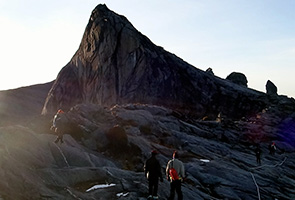
A large avalanche of earth and rock on Mt Kinabalu following a 6.0-magnitude earthquake which struck Sabah on Friday. Some 137 climbers were trapped on the mountain
after the quake hit.
Q2: Do the moving plates affect areas on the Peninsular?
A: Sabah is the closest part of Malaysia to the Philippines and Sulawesi in Indonesia thus, it will experience more compression force than Sarawak and Peninsular Malaysia.
Q3: More than 30 aftershocks were recorded by the Meteorological Department following the earthquake on Friday. How long will this continue?
A: The aftershocks are smaller tremors that occur while the Earth’s crust settles. Usually the aftershocks will continue up to two to three weeks.
Sometimes, smaller tremors can occur before the strong quake hits, and this is called Foreshocks. Foreshocks are relatively smaller earthquakes that precede a larger earthquake.
Q4: The people have become afraid after the quake struck and they fear that Mount Kinabalu will erupt in the near future. Will it erupt?
A: What occurred in Ranau is not linked to volcanism, which is only possible in Tawau and Semporna, where an explosion occurred several hundred years ago. Volcano craters are still visible in Tawau.
Mount Kinabalu will not erupt, as the igneous intrusion that formed Mount Kinabalu is caused by the compression of the three Plates mentioned previously.

An injured child being attended to by search and rescue personnel before being brought
to the Ranau Hospital.
Q5: Is there a possibility that Sabah will be struck by another strong tremor like the one on Friday?
A: Strong tremors in Ranau will continue to occur whenever the stored energy exceeds the Earth’s ability to store it. This happens on a regular basis.
In the case of Ranau, it happens at an approximate rate of every 25 years, with the first being recorded in 1966 measuring 5.3 on the Richter scale.
This was followed with a 5.2-magnitude earthquake in 1991.
Q6: What causes an earthquake?
A: Earthquake tremors are the result of a rapid release of energy where seismic waves move in all directions from the source, known as a focus.
A point on the Earth's surface above the focus is called the earthquake centre. For example, the centre of the Ranau earthquake is near the peak of Mount Kinabalu.
This means the focus of the earthquake was underneath its centre; in this case it was 10km below the centre. This is what caused the massive landslides.
Tremors usually occur along faults, or longitudinal cracks in the earth that have bent and snapped back in what is called an elastic rebound.
Imagine taking a plastic ruler and bending it. After a certain point it will break and release all the energy put into it from our effort to bend it. When an earthquake happens, the rocks in the earth are behaving in a similar fashion.

Mt Kinabalu guides carrying down an injured child following a 6.0-magnitude earthquake that struck Sabah on Friday.
Q7: Then what’s the meaning of Seismic?
A: Seismic waves refer to the energy that is released after an earthquake during the elastic rebound. There are three types of seismic waves – primary, secondary shear waves and surface waves.
Primary waves are the fastest and move forward and backwards like a lurching car. This can cause dizziness, as surface waves are also moving from left to right. All three waves can be felt almost at once if one is close to the earthquake’s centre.
About 80% of earthquakes occur in the Pacific Rim due to a collision of tectonic plates in the Earth’s crust. The rest occur outside those regions in areas with active fault lines.
- Source: Astro Awani
No comments:
Post a Comment